
VIDEO: The Aroostook Emergency Management Agency (EMA) has a new tool designed to give crews real-time views of dangerous situations from above: a drone.
Officials say the drones can be used to monitor river ice jams and spring flooding, as well as spot and track wildfires across the county.
“We can sit up in one spot on the river and go up and down the river getting a better perspective of the area,” said Derrick Ouellette, deputy director of Aroostook EMA.
In a county as large and rural as Aroostook, that perspective makes a big difference, giving emergency crews real-time information for up to 40 minutes at a time, without putting boots on the ground.
“It’s going to be a really good tool. And especially since it was made in the U.S. It is going to be a lot more secure to use than other things that come off the shelf,” Ouellette said.
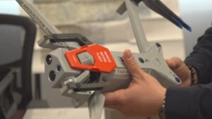
The drone kit, which includes infrared attachments, multiple batteries, and a waterproof, impact-resistant case, cost about $20,000 funded through a grant Ouellette applied for more than two years ago.
“The biggest part for me was probably getting the SOPs and policies in place and getting the grant for the drone,” Ouellette said.
With a licensed drone team in place, officials say the technology will help them quickly assess situations from above so they can better respond on the ground.
“Someone might have a house or a camp somewhere, and they might be away, and it’s just a way for them to get visibility. Could be situational awareness with big events or something drastic happening in the county,” Ouellette said.
Ouellette says the team will be available to assist other departments through mutual aid, but their primary focus is on flooding and wildfires. With spring flood season approaching, Ouellette says the drone is a game-changer.