
The PulsePoint Foundation, a public nonprofit 501(c)(3) that develops applications supporting public safety agencies, announced an integration with Critical Response Group (CRG), the nation’s leader in critical incident mapping data. Through the integration, the nationwide catalog of CRG’s Collaborative Response Graphics® appear directly within PulsePoint Respond incident maps, equipping responding personnel with actionable intelligence for pre-incident planning and real-time response.
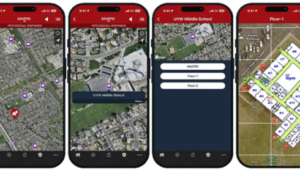
CRG’s critical incident mapping provides situational awareness for multi-agency response in complex structures and during large-scale events. Professional responders in more than 5,500 PulsePoint-connected communities now have access to these highly detailed standardized emergency response maps directly within the same application they rely on for critical information during incident response and coordination.
CRG’s 70,000+ mapping products support response operations across schools, healthcare facilities, commercial buildings, and other critical infrastructure environments, nationwide.
PulsePoint Respond is designed to provide responding personnel with focused, incident-relevant information including hydrants, highway cameras, live unit locations and real-time CAD narratives. CRG response plans extend this capability, improving situational awareness, supporting unified command, and helping all responders operate more safely and efficiently during complex incidents.