
VIDEO: Temps are heating up and drying things out.
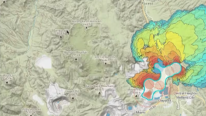
While wildfires can happen anytime, dry conditions can make them spread faster, and one of the hardest things to do is predict how a fire will spread.
Satellite technology and AI can help with that.
For the last year, the Fry Fire District has been participating in a pilot program with OroraTech, a company that uses satellites to assist crews on the ground.
Fry Fire Chief Mark Savage said it is more crucial now than ever before.
“What we anticipate as a pretty significant fire season looking forward,” Savage said. “It’s going to get hotter, it’s going to get drier. Time is going to be of the essence. The sooner we can find out about these fires, the better.”
Using infrared sensors, the satellites detect hotspots at any time.
Robert LaMacchia, director of accounts for Orora, said the company’s satellites can cover areas that can’t be monitored as often as they should be, adding that they’ve been helping different fire districts and departments across the globe.