
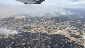
As the Morrill Fire took off from a field in Arthur County on March 12, people from across the state – and others based throughout the U.S. – were watching as it quickly raced across hundreds of thousands of acres.
A team of researchers was tracking the fire from the National Oceanic and Atmospheric Administration (NOAA) offices. Mike Pavolonis, wildland fire program manager at NOAA’s Satellite and Information Service, saw the flames break away and run for miles on a new AI-powered fire detection tool called the Next Generation Fire System (NGFS).
“We watched it from ignition,” Pavolonis said. “The very, very quick intensification of the fire and then just the unbelievable spread rate during certain periods of time – you could see it clearly unfold on satellite from space, and so I can’t imagine what it was like on the ground.”
Just two days later, the Morrill Fire had burned hundreds of thousands of acres and easily blew the lid off records held by previous Nebraska wildfires. And another mammoth fire was growing in more-populated areas in Lincoln and Dawson counties, forcing people to leave their homes and their fields as crews worked to back off the flames.
The system was unveiled in 2025 and has been used by most National Weather Service offices across the country, including in Nebraska. The technology uses satellites that can scan new imagery over an area covering multiple states every minute and generate a fresh image of the entire contiguous U.S. every five minutes. Once a fire is burning, NGFS can provide real-time weather and fire monitoring, according to NOAA.
“We wanted to build an automated system that was capable of extracting information on fires in a way that was consistent with how a human expert does it,” Pavolonis said. “Not to replace the human expert, but to be that force-multiplier for the human decision maker, because these satellites are taking images every minute. And then provide that information back to the human decision maker without having to comb through an absolute mountain of data.”
Nebraska Public Media
The post As Nebraska’s largest wildfire ignited, new and old tools helped track its movement appeared first on Daily Dispatch.